
manipur

Manipur pronunciation ) (Meitei: মণিপুর maṇipur) is a state in northeastern India, with the city of Imphal as its capital. Manipur is bounded by the Indian states of Nagaland to the north, Mizoram to the south and Assam to the west; it also borders Myanmar to the east. It covers an area of 22,347 square kilometres (8,628 sq mi).
The Meeteis, who live primarily in the state's valley region, form the primary ethnic group. Their language, Meeteilon (also known as Manipuri), is also the lingua franca in the state, and was recognized as one of the national languages of India in 1992. The Kukis or the Zoumis (people belonging to Zo descendants) and Nagas live in the hills of the state. Manipur is considered a sensitive border state.
Foreigners entering Manipur (including foreign citizens born in Manipur) must possess a Restricted Area Permit, which can be obtained from the Foreigners' Regional Registration Office in the "metros" (Delhi, Mumbai, Kolkata, Chennai) or certain other state government offices. Permits are valid for only 10 days, and visitors must travelonly on tours arranged by authorised travel agents, in groups of four. Furthermore, they may come to Imphal only by air and are not permitted to travel outside the capital.
History
Manipur came under British rule as a princely state in 1891. This ended the independent status of the Kingdom of Manipur, the last kingdom to be incorporated into British India.
During the Second World War, Manipur was the scene of many fierce battles between the Japanese and the Allied forces. The Japanese were beaten back before they could enter Imphal, and this proved to be one of the turning points of the War.
After the War, the Manipur Constitution Act, 1947, established a democratic form of government with the Maharaja as the Executive Head and an elected legislature. In 1949, Maharaja Bodhchandra was summoned to Shillong, capital of the then Indian province of Assam. The legislative assembly was dissolved on the integration of the state with the republic of India in October 1949. Manipur was a union territory from 1956 and later became a full-fledged state in 1972.
Maharaja Bhagyachandra, king of Manipur from 1759–98, is a legendary figure in Manipur. The inventor of the Ras Lila dance, he is also credited with spreading Vaishnavism in Manipur after his grandfather Pamheiba Rajah made Hinduism the official religion and for creating a unified Manipur.
There has been an separatists movement in Manipur since Indian independence, with several groups engaged in violent actions in order to achieve their goals..
Special permission must also be obtained for those who wish to enter Manipur, as it is considered a "sensitive area" on account of its political troubles and geographical location.
Geography, Vegetation and Climate
Geography:
Manipur is one of the eight states of Northeast India, and one of the Seven Sister States. The state is bounded by Nagaland in the north, by Mizoram in the south, by Assam in the west, and by the borders of the country Myanmar in the east as well as in the south. The state capital of Manipur is Imphal. The state lies at latitude of 23°83’N - 25°68’N and longitude of 93°03’E - 94°78’E. The total area covered by the state is 22,327 km². The capital lies in an oval-shaped valley of approximately 700 square miles surrounded by blue mountains and is at an elevation of 790 metres above the sea level. The slope of the valley is from north to south. The presence of the mountain ranges not only prevents the cold winds from the north from reaching the valley but also acts as a barrier to the cyclonic storms originating from the Bay of Bengal.
There are four major river basins in Manipur State, the Barak River Basin (Barak Valley) to the west, the Manipur River Basin in central Manipur, the Yu River Basin in the east, and a portion of the Lanye River Basin in the north. The total water resources of the Barak and Manipur basins have been estimated to be 18.487 cubic kilometres in the form of annual yield.[citation needed] The Barak river, the largest river of Manipur, originates in the Manipur Hills and is joined by a number of tributaries such as the Irang, Maku, and Tuivai. After its junction with the Tuivai, the Barak River turns north and forms the border with Assam State, and then enters the Cachar District of Assam just above Lakhipur. The Manipur river basin has eight major rivers: the Manipur, Imphal, Iril, Nambul, Sekmai, Chakpi, ThoubalKhuga. All these rivers originate from the surrounding hills. and
Almost all the rivers in the valley area are in the mature stage and, therefore, deposit their sediment load in the Loktak lake. The rivers draining the Manipur Hills are comparatively young, due to the hilly terrain through which they flow. These rivers are corrosive in nature and assume turbulent form in the rainy season. Important rivers draining the western area include the Maku, Barak, Jiri, Irang and Leimatak. Rivers draining the eastern part of the state, the Yu River Basin, include the Chamu, Khunou and other short streams.
Physiographically, Manipur may be characterised in two distinct physical regions - an outlying area of rugged hills and narrow valleys, and the inner area of flat plain, with all associated land forms. These two areas are not only distinct in respect of physical features but are also conspicuous with regard to various flora and fauna. The valley region would have been a monotonous, featureless plain but for a number of hills and mounds rising above the flat surface. The Loktak lake is an important feature of the central plain. The total area occupied by all the lakes is about 600 km². The altitude ranges from 40 m at Jiribam to 2,994 m at Mt.Iso Peak near Mao Songsang.
The soil cover can be divided into two broad types, viz. the red ferruginous soil in the hill area and the alluvium in the valley. The valley soils generally contain loam, small rock fragments, sand and sandy clay, and are quite varied. On the plains, especially flood plains and deltas, the soil is quite thick. The top soil on the steep slopes is very thin. Soil on the steep hill slopes is subject to high erosion, resulting in gullies and barren rock slopes. The normal pH value ranges from 5.4 to 6.8.
Districts:
Manipur has currently nine administrative districts.
| District | Area | Population | Headquarters |
|---|---|---|---|
| Bishnupur | 496 | 208,368 | Bishnupur |
| Churachandpur | 4570 | 227,905 | Churachandpur |
| Chandel | 3313 | 118,327 | Chandel |
| Imphal East | 709 | 394,876 | Imphal |
| Imphal West | 519 | 444,382 | Imphal |
| Senapati | 3271 | 283,621 | Senapati |
| Tamenglong | 4391 | 111,499 | Tamenglong |
| Thoubal | 514 | 364,140 | Thoubal |
| Ukhrul | 4544 | 140,778 | Ukhrul |
Vegetation:
The natural vegetation occupies an area of about 14,365 km². which is nearly 64% of the total geographical area of the State. The vegetation consists of a large variety of plants ranging from short and tall grasses, reeds and bamboos to trees of various species. Broadly, there are four types of forests below:
- Tropical Semi-ever Green.
- Dry Temperate Forest
- Sub-Tropical Pine
- Tropical Moist Deciduous
Teak, Pine, Oak, Uningthou, Leihao, Bamboo, Cane, etc. are important forest resources growing in plenty. In addition, rubber, tea, coffee, orange, and cardamom are grown in hill areas. Food and cash crops make up the main vegetation cover in the valley.


Climate:
The climate of Manipur is largely influenced by the topography of this hilly region which defines the geography of Manipur. Lying 790 meters above sea level, Manipur is wedged between hills on all sides. This north-eastern corner of India enjoys a generally amiable climate, though the winters can be a little chilly. The maximum temperature in the summer months is 32 degree C. In winter the temperature often falls below zero, bringing frost. Snow sometimes falls in some hilly regions due to the Western Disturbance. The coldest month is January, and the warmest July. The ideal time for tourism in the state, in terms of climate, is from October to February, when the weather remains bright and sunny without the sun being too hot. The state is drenched in rains from May until mid-October. It receives an average annual rainfall of 1467.5 mm. However, the rain distribution varies from 933 mm in Imphal to 2593 mm in Tamenglong. The downpour ranges from light drizzles to heavy showers. The normal rainfall of Manipur enriches the soil and helps in agricultural processes and irrigation. The South Westerly MonsoonBay of Bengal and heads towards Manipur, hits the eastern Himalaya ranges and produces a massiv picks up moisture from the e amount of rain in the state.


Tourism
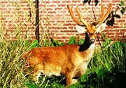
Manipur as the name suggest is a land of jewels. Its rich culture excels in every aspects as in martial arts, dance, theater and sculpture. The charm of the place is the greenery with the moderate climate making it a tourists' haven. The beautiful and seasonal Shirui Lily at Ukhrul (district), Sangai (Brow antlered deer) and the floating islands at Loktak Lake are few of the rare things found in Manipur. Polo, which can be called a royal game, also originated from Manipur. Some of the main tourist attractions are:
Imphal (Capital):
The city is mainly inhabited by the Meitei and it is just 7 km from the airport of Manipur (Tulihal Airport). The district is divided into East and West and the recently constructed sports complex (Khuman Lampak Sports Complex) is also one of the attractions comprising of every thing, from a cyclists velodrome to the main stadium. Most of the imported goods are sold here at its Paona Bazar, Gam-bir Sing Shopping Complex and Leima Plaza.
Keibul Lamjao National Park:
Keibul Lamjao National Park, 48 km away from Imphal is an abode of, rare and endangered species of Brow Antlered deer (also known as Sangai). This ecosystem is home to 17 rare species of mammals. The greenery of the place and the moderate temperature makes a pleasant experience to visit.
Loktak Lake (Freshwater Lake):
Loktak Lake is the lake where most of the people of Manipur get their share of fish meat. The special treat to watch are the floating islands popularly known as Phumdi which is made out of the tangle of watery weeds and other plants. With a nominal fee, people can hire small boats and see this fascinating way of living on these floating islands. The wetland is swampy and is favourable for a number of species to thrive on. It is in the district of Moirang. Etymology of Loktak is "Lok = stream and tak= the end".
Manipuri Dance (Ras Lila):
 |
A classical form of Manipuri dance based and inspired by the theme of Lord Krishna and his beloved, Radha love story and the devotion of the Gopis (companions) towards Lord Krishna. This graceful and slow movement of the dance makes it one of the most acclaimed classical dances of India. The costume is elegant, as there are nicely embroidered clothes that give luster to the beauty of the art.
Menu
News
tourism statistics
07/10/2009 21:01———
Blog
Do's and Don'ts of Travel
07/10/2009 21:08———
 |